The family was scheduled to drive out to MI for a family birthday with my in-laws. I really wanted to go, but I do have a lot of things going on and felt that it would be better from a work/life balance perspective to keep going, especially since some of the activities are of the away from home variety anyway.
So, instead of driving 11 hours, I suggested that I fly them to Toledo and return home. They picked up a rental car in TOL to drive the remaining two hours, and I flew back to Leesburg. The flight out was very uneventful with very little haze or clouds. We even had a slight tailwind.
The return flight was equally uneventful except that the time to climb was noticeably shorter. I made a PIREP just west of the BSV VOR. After the report I checked back in with Cleveland center and decided to monitor 121.50. Much to my surprise, I was receiving a very strong Emergency Locator Transmitter (ELT) signal. This was a first for me. I reported that to the Center controller who said that he had received other reports at all altitudes as well. A quick check of the GPS showed that I was passing over the New Philadelphia airport (KPHD). I suspect there was an airplane transmitting a signal on the ground there.
Friday, August 18, 2006
Tuesday, August 08, 2006
Flight of the Guinea Pig
I was selected to participate in a NASA research study a few weeks ago, so yesterday I flew down to Newport News (KPHF) for an interview with the research team. I also spent some time wearing the Oculometer for calibration purposes. The goal of the study is to evaluate GA piloting performance while interacting with datalink weather services.
The flight down was mostly uninteresting until just northwest of the airport. Apparently there was some maneuvering traffic below me that I passed over and avoided, but never saw. Visibility was pretty bad and I will log a good portion of the flight as actual. The haze was thick until I got closer to Norfolk.
Upon rollout and landing on runway 20, I turned onto Charlie and taxied to Mercury at about 1:2opm for a 2:00pm appointment. The sequence was textbook in terms of the utility of GA flight in action. The project folks had arranged a car for me. I parked the airplane with directions from the lineman, hopped out, grabbed my bag, closed up the airplane and put the cover on. I grabbed the keys and jumped in the rental car, drove the 11 miles to the facility and was on time for my 2:00pm appointment, which was interesting and fun. I learned a lot about the MX20, a device I have really never touched. I will be using it a lot when I pilot the NASA Stationair around VA NC and/or WV next month.
By 6pm, I was following the Garmin 3200 directions back to the airport in the rental car. I filed a flight plan enroute, and despite the heat and humidity, learned that the storms prognostication for 4pm onward would be no factor on the way back to Leesburg. After a quick human refueling courtesy of the golden arched restaurant, and some bio-recycling, it was time to taxi.
The clearance was HPW RIC COATT4, but nearing BRV, it was fly a 340 heading forever. The flight at 6000 was punctuated by continuous light chop from RIC to BRV, most likely somewhat a by-product of some intense convective activity NE of our position. The other noteworthy part of the cruise portion of the flight was the RJ flying the COLIN departure from RIC that was capped at 5. I was in the way at 6. Once in sight I approved the controllers request for visual separation and the jet streaked by about 2 miles ahead climbing to 9000.
Passing HEF on the western tour to JYO, and now well inside the ADIZ, I cancelled the IFR to join the Route 15 arrival at 1400'. The nice surprise, in addition to the direct destination, was the 141 knot groundspeed, which during cruise had been stuck at 121 knots. With the beacon in sight at 8 miles, I called it in with ATC and they dropped radar services and approved the frequency change. The airport was very quiet, so, I joined the crosswind for the 17 downwind, and completed a very uneventful flight.
3.1 hours on the meter.
Friday, July 21, 2006
Flight to Teterboro
I received a request Monday to fly an Angel Flight mission to NY City on Tuesday. My passenger snapped a few pictures.

Here is short final for 19 at Teterboro, (KTEB) (yeah well, this is called S-turns on final to allow the jet to get across the runway- yeah, that's it ;) )

Giants stadium in view on the departure off 24.

I'm glad we'll be turning to the left soon. No interest in penetrating that kind of IMC.

Unfortunately, the winds were aligned with our desired direction of flight.

The steady steed awaits another day of flying adventure.


Here is short final for 19 at Teterboro, (KTEB) (yeah well, this is called S-turns on final to allow the jet to get across the runway- yeah, that's it ;) )

Giants stadium in view on the departure off 24.

I'm glad we'll be turning to the left soon. No interest in penetrating that kind of IMC.

Unfortunately, the winds were aligned with our desired direction of flight.
The steady steed awaits another day of flying adventure.

Sunday, May 28, 2006
Missed on Memorial Day weekend
We scheduled a flight up to Hamilton, NY (H30) for the long weekend in N2871R. The weather was warm and moist, and the circulation and instability caused by low pressure descending eastward out of the Great Lakes made the weather analysis complex. However, the satellite showed that the sky cover was mostly broken across all of PA with a few complexes of heavy and severe precip. I decided to delay the flight to let the afternoon convection die down.
The number one rule for safe IFR in areas of thunderstorms is to stay visual with and avoid the weather. Closer to departure time, a narrow complex of thunderstorms stretched from Latrobe past Harrisburg moving east with a large area of convective activity east of Pittsburgh. Our route of flight was over Harrisburg, and the second rule for safe thunderstorm avoidance is to avoid flights cross/through lines of activity. If that is the plan, see rule one above.
We received our clearance out of Leesburg which was immediate right turn off runway 17, direct STILL, radar vectors MRB, HGR v377 HAR and on up through PA, passing over Selinsgove and Williamsport, then up over Binghamton and then destination.
Climbing out of Leesburg just after 8pm we were quickly on our way to HGR; P-40 was expanded, so we got the western routing, but it wasn't too bad. Closer to HGR, we were turned to SCAPE on v377, and then direct HAR. We checked in with HAR approach, and advised we could use some help with the weather. Harrisburg concurred and said that closer to HAR they would probably have to route us east.
It wasn't long after that when HAR recommended a deviation left of course to avoid activity west of victor airway 31. When I asked about direct SEG, we were told that the line of
weather was currently there as well. We could see the weather off our right wing and continued northbound toward clear skies. The late evening sun was still illuminating faint strands of high cirrus ahead - a sign that large weather complexes were not on our route of flight. So far so good.
As we neared Williamsport, the weather to our east was headed away and the light show we got near Selinsgrove came to an end. I asked NY center for a frequency change to talk to Flight Service. I got two responses to the call (Competition at the FSS. ;) ) The weather at IPT was reporting in as 1SM visibility, but from altitude it looked much better than that - the weather from flight service was a few minutes old. Syracuse weather was still overcast at 4000.
As the darkness prevailed, the visibility was decreasing and the gloomy view ahead suggested that we would soon be entering some weather. Binghamton airports started going in and out of view, and the lights below disappeared. IMC. Binghamton approach soon handed us off to Syracuse, and we got ready to shoot the GPS-A into Hamilton (H30).
The approach controller reported twice that moderate precipitation had enveloped the approach area, and I knew pretty well that it was just rain- there was nary a bump since we entered the weather. The rain got very heavy as we descended down to 5000, but did not last long. We crossed the VOR at about 4000 on a descent down to cross hutch at 3500. I stayed higher and then started the descent for the airport. As we got down to 2300' I looked for the airport lights I had turned on. They were already directly below us and I could see ragged looking clouds surrounding the airport.
Knowing that I needed greater than 2SM visibility, not able to determine whether or not I could keep a visual on the airport, and the town lights shrouded in haze to the south, it was an easy decision to avoid the sucker approach and power up for the missed approach. We turned back for HUTCH and called Syracuse approach. When queried for intentions, it was time to head for Syracuse.
We were told to expect the ILS 28, vectors through the approach course for the sequence. Ok. The airplane ahead of us reported ceilings at 850 feet. I picked up the lights at about 900' and the runway at about 800 feet, the ALFS-2 approach lights bright and welcoming. The water covered runway shimmered below and we continued the approach. I can honestly say that it was my best landing ever - there was no thud, whatsoever.
We taxied down to Landmark at about 11 and were glad to see they were still open. Since the rental car companies were well closed, the FBO lent us the crew car overnight and we headed back to Hamilton... through the foggy woods to gram's house.
I got up the next morning to return the crew car promptly and ferry the plane back to Hamilton. I spent the morning working on the airplane, adding oil and gas, and generally getting it re-organized. The slight slant of the ramp had allowed the fuel to migrate to the downhill tank, but that was easily corrected.
The weather finally lifted at about 1 and I logged the GPS-A approach again with the airport coming into view this time in good visibility. I cancelled IFR in the air. Marybeth and the kids were at the park about 1 mile or so from the airport and heard me fly in, so they came over and picked me up. We fueled and secured the aircraft. As we did, the skies cleared from overcast to scattered cumulus.
Friday, May 05, 2006
Hastening their own end
The controversy during the past year or so about the Aviation Trust Fund and the implementation of user fees instead of airline ticket taxes continues to expand. The consequences of this are profound, and in a nutshell, if the proposal by the FAA is adopted, it will lead to the demise of the Air Traffic Control System.
The immediate consequences for general aviation will be diminished safety. Some other consequences, good and bad:
1) The number of GA VFR flights will increase, the number of IFR flights will decrease
2) The economic barriers to entry for ADS-B and other technologies that support in-situ (in cockpit) flight safety will come down.
3) Class E airports will increase in value
4) Congestion at larger airports will become worse to the point where VFR entry will be denied (the airlines will gain a foot hold over their GA competitors to service larger airports exclusively - in some cases this is true already.)
Eventually, GA flight operations will minimize their use of ATC in the NAS. The airlines will be paying less for the system. A gap will develop and there will be funding shortfalls - shortfalls that do not exist today. The airlines will resist any increase to the fees, and lobby for down-sizing the ATC system in favor of technology in the airliner that can provide the same level of safety for the flying public as the ATC system, possibly as proven by GA (true or not, that could be one argument).
On the surface, this would appear to be a pretty good result. Unfortunately, aviation safety is extremely complex. The agenda of the airlines is not safety, it is short-term profitability. They do not foresee the impacts on flight safety that this will have - they just don't see it on the radar as an issue for them. But that is where they are wrong, because the overall incredible level of safety we enjoy today will be lost, perhaps irreparably, and the impact that will have on profitability will be even more significant.
Thursday, April 27, 2006
ADIZ Impact
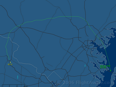
Here is a poster-child flight for the impact of the DC ADIZ/FRZ. One might call it a "Great circle route". The flight originated at Leesburg, VA and flew to Stevensville, MD.

More dangerous posts
See DayJet post disclaimer below and then read this article:
http://tinyurl.com/m8lla
Comments:
1) Leave Alaska alone!
2) What would be the economic effect of eliminating "willing seller(s)?" - see article referring to new FTC powers to prosecute retailers with "unlawfully" high gas prices.
What is an "unlawful gas price?"
Well before any new laws are passed, I would like to request Thursday as my day to buy auto fuel.
"Please, sir, I want some more."
Wednesday, April 26, 2006
Please Tax the Oil Companies!!!
Congress needs to act; it is an election year and we’ll be voting.
In addition:
There is no doubt that all of these efforts will bring the higher gas prices necessary to make some tangible progress in actually finding viable alternative fuel sources.
In addition:
- Please extend the tax incentives for purchasing large SUVs that weigh more than 6000 pounds.
- Also, keep enacting environmental protection legislation with unreasonable timeframes for implementation
- Please make sure the public is fully in-the-know well in advance so that we can have nationwide panic which will lead to even stronger short term demand.
There is no doubt that all of these efforts will bring the higher gas prices necessary to make some tangible progress in actually finding viable alternative fuel sources.
Tuesday, April 25, 2006
DayJet Announces Service Region, Plans
DayJet announced that it will serve all the airports in the FAA Southeast US Airport Facility Directory (A/FD) ... almost. Readers from Kentucky should know they will not be included in the initial service launch.
As for the reason for this post, I almost hurt myself laughing when I read this.
WARNING: The quote presented below has been known to cause loss of physical motor control. This weblog accepts no responsibility whatsoever for any injury that may result from continuing to read this post.
I have lived long enough to learn that there are a several simple rules to live by, for example:
1) Avoid consumption of mass-produced fish
2) Avoid buying the first model year of a new car design
NEW: 3) Avoid air travel in newly designed, mass-produced aircraft.
Scary. If they can, great. I'll wait until Eclipse produces serial number #601 about 5 years from now to work out the bugs before I hop on board.
Here is Cessna's production in 2005 for comparison.
Now, here is some insight into Eclipse:
As for the reason for this post, I almost hurt myself laughing when I read this.
WARNING: The quote presented below has been known to cause loss of physical motor control. This weblog accepts no responsibility whatsoever for any injury that may result from continuing to read this post.
DayJet has 239 Eclipse 500s on firm order, plus 70 options, all planned for delivery within 24 months of beginning operations. -- Graham Warwick, Flight International
I have lived long enough to learn that there are a several simple rules to live by, for example:
1) Avoid consumption of mass-produced fish
2) Avoid buying the first model year of a new car design
NEW: 3) Avoid air travel in newly designed, mass-produced aircraft.
Scary. If they can, great. I'll wait until Eclipse produces serial number #601 about 5 years from now to work out the bugs before I hop on board.
Here is Cessna's production in 2005 for comparison.
During the year, Cessna delivered 249 Citation jets, 822 single engine pistons, and 86 Caravan single-engine turboprops.
Cessna Aircraft Company is a subsidiary of Textron Inc. (TXT), a $10 billion, multi-industry company with 46,000 employees in 36 countries.
Now, here is some insight into Eclipse:
And as it ramps up production to 130 jet planes this year, Eclipse will nearly double its work force to 1,000 employees by the end of the year, Raburn said.
Sunday, April 16, 2006
Flight aware upgrade
Flightaware now provides historical flight track map overlays. Outstanding!
Here is the flight track for the ORH-TTN flight last week.

Here is the flight track for the ORH-TTN flight last week.
Saturday, April 08, 2006
Cheat -ed / -ing on return
With a warm front stretching from Atlantic City to Danville, and a strong low in the midwest the weather was less than ideal when I got to the KORH airport to come home. The reported weather was OVC007, strong winds on the surface and enroute (40-60 knots forecast), and wind shear on the TAF. After a lengthy study of the weather computer and chat with flight service, it looked like I could fly to Trenton (TTN). The flight plan I pre-filed the day before was completely out the window.
Once the tower found the new flight plan, I got a full route clearance to TTN, and taxiied to rwy 29. The clearance was runway heading, vectors ORW v16 DIXIE v276 RBV KTTN, 3000, expect 6000 in 10. I started messing with the weather pages in the G1000 again - big mistake. More on that later.
There was a good bit of turbulence in the climb, but nothing outrageous. Cleared up to 6000 and heading 250, I cleared the clouds at 5000 feet. Total IMC time, like 5 minutes maybe. Cheated. I was eventually cleared south to ORW. Arriving north of ORW, the clouds faded and by the time I hit the LI Sound, skies were clear above, and below. Over Long Island I saw a few distant flashes of activity to the West-Northwest. When I asked NY approach about any weather, the response was - nothing apparent anywhere.
The reason I had to ask NY about the weather, despite having XM Weather on the G1000, was that I had managed to turn it off. There is a "Done" softkey on the AUX page. This should be relabeled the "kill" key - it effectively disables the data link function. Upon further study of the purpose of that button, there is no information on what it does, except to denote its use when first activating the system. So, at a time when weather would have been nice to have, I had none.
But then, I really didn't need it. The trip to TTN was very uneventful. I landed, got self-serve fuel, refiled, and reviewed the weather. With the radar trend showing a slot opening up west of JYO, it looked like a very doable flight. All that and a phone call to Mike to discuss the G1000 WX problem, I was on my way within about 30 minutes. The fuel farm is to the left rear of the FBO building when pulling up. I will remember that as TTN is a good stop.
Departing runway 24, I called Phili approach to activate IFR. The tower had closed. After a few minutes, I was cleared to JYO via direct MXE v408 ROBRT AML JYO at 6. Phili had me hold at 5000 as can be seen in the Flightaware track log.
It was definitely a bumpy flight and the log shows the horrendous ground speeds. As such other traffic was overtaking me once cleared to 6000, so I was assigned 7000, but given direct JYO - hard to beat that. I flew through one rain shower and the autopilot fought with the turbulence with occasional excursions through 20 degrees of bank and one chart flipping jolt.
For this flight though, I had full weather again and just monitored the radar images. Cheating. It was clear VMC for the whole trip with ceilings at about 8 or so. 44 miles and still 30 minutes from JYO, I had the beacon in sight. With 405 total flight hours as of this trip, I have still not had a weather scenario occur that convinces me that cockpit weather is as valuable as it costs. My thinking is that if it becomes a necessity while in flight, something is wrong with the pre-flight planning process. Yes, weather changes quickly and often, but at most GA airspeeds, it's not that much change. Maybe there is some regional weather variable to this.
As usual for a late night flight, I cancelled IFR once firmly planted on runway 17. 1.8 hours from TTN to JYO - 147 miles - or an avg gs of 82kts. Yikes!
Friday, April 07, 2006
JYO-ORH via JFKrazy
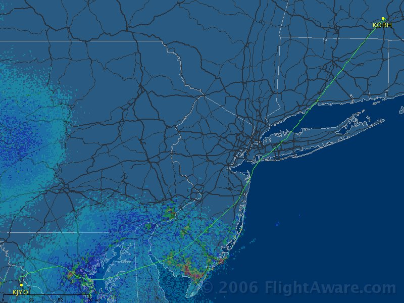
Leesburg, VA to Worcester (that's "wistah" for those of you who grew up south of the Mason-Dixon line) in 2.5 hours. Wheels left runway 35 at 1820, landed ORH runway 29 at 2055. Here is the flight track.

It was a fun flight. I called up clearance delivery at JYO and heard the magic words - "Cleared as filed..." Woohoo!
STILL WOOLY BAL V268 ENO V16 JFK V229 WITNY
Turning east out of JYO to WOOLY, ground speed was over 160 knots, and over BAL and down v268 speeds topped out at 171. Making the turn over BROSS, and heading north, speeds quickly slowed to 145, and continued a southbound trajectory toward 130 for most of the second half of the trip.
McGuire descended me down to 5000 passing CYN, only to have NY turn me 40 left and climb back to 7000 15 miles from JFK. The controller in the south departure sector off Kennedy was non-stop instructions, until the Saudi heavy jet started a two minute (that's not an exaggeration) rant about flight plans - on the wrong frequency. I would have to guess dispatch was on the other end. Oops. The NY controller gave him an earful, demonstrating how a similar dressing down can be done in only 12 seconds. ;)
After the vectored climb, it was direct Kennedy again. Then soon after passing over top the field, I was given 090 for 10 miles, then 30 left to join the airway soon after. The next controller cleared me direct Hartford after I checked in with a request for BDR, as I headed out over Long Island sound. That soon became direct ORH for the visual 29.
Sunday, April 02, 2006
Spinning Decathlon
What a nice day to fly! The winds were light with a few scatterings of cumulus clouds at 4500'. Went over to VKX to work with Adam Cope and his Super Decathlon to meet the flight training requirements for stall spin awareness.
Here is a picture of the Super Decathlon.

After an extensive briefing on stalls and spins, and a lengthy suit up process with the chute, the flight began with some stalls and dutch rolls. This was great since it really brings home the experience of adverse yaw.
Climbing up to 3500' on the fringe of the DCA class bravo, we then performed some falling leaf stalls. In this maneuver, the goal is to understand the power of rudder authority. With the airplane set up in a stall, opposite rudder is applied to 'catch" the falling wing. As such, the airplane wallows in a nose up descent as the wings slowly oscillate back and forth from high to low, just as a leaf does. Of course, with good feet skills, this can be minimized a great deal.
Then it was time for incipient spins and fully developed spins. With the airplane stalled, kick the rudder and over we went. Two turns and then it was release the stall and pull out from the dive. Simple.
After a couple of those to the left and right, we did two fully developed spins with 5 rotations from 4500'. After two rotations the spin was fully developed and releasing the back pressure had NO EFFECT! The spin tightened and the rotation increased - a stabilized spin. Now, full opposite rudder to stop the rotation, and pull out of the dive. The first one came out at 2500' and 4.4 G's! 2000' of altitude loss in about 15 seconds (if that). The others also were good for 2000'...exactly. Weird, but most things in flying are mathematical, so not too surprising.
After another one of those, we were basically done. My stomach (more literally my brain) had had enough spinning. A simple three point landing (my first ever in a taildragger), and it was
a day. 1.0 on the hobbes meter. Will have to go do it again some time (on purpose) - it was a lot of fun!
Thursday, March 30, 2006
$200M and counting
The inanity of antimissile technology for airliners continues. It reminds me of nuclear deterrence. The only logical hope is that by having something, it will deter/persuade terrorists to pick a different target.
This approach was costly then and it is even more costly now. As a society, we continue to struggle with an understanding of risk management, cost/benefit analysis, etc., when it comes to security.
Unless this system is just as effective against rocket-propelled anything's (grenades for example), this is a complete waste of taxpayer revenue.
Why not spend $200M on making sure that FBI agents have email and others tools they need so they can track down terrorists before they have a target in their sights?
Hooters Buffaloed by Messy Industry

Well, Hooter's Air is the latest casualty in the domestic airline travel industry. I thought the quote by Bob Brook's in the AP article is concise and brutally accurate. "The flying industry is in a terrible mess. ... I've got a fair amount of money, but I don't have enough to fix this animal."
Thursday, March 23, 2006
What's in your hangar?
As fate would have it, I converted a small windfall from some intangible paper shares with no market value into a tangible, flying asset.
Wednesday, March 22, 2006
Pre- Sun N Fun FAA Bloopers
Reviewed the video today for the Sun N Fun event in Lakeland, FL (KLAL) next month. Two things struck me watching the video produced by the FAA:
1) The introduction is narrated by a pilot who jumps out of his airplane and hangs onto the propeller like that's a safe idea... and,
2) The arrival procedure includes (practically requires) low altitude overflight of a power plant. The FAA might want to review its own FDC NOTAM 04/0811. Or more logically, rescind the NOTAM since it very little, if any, deterrence or enforcement value.
Tuesday, March 21, 2006
NTSB releases Stafford, VA preliminary accident report
It took awhile, but the preliminary accident report for a recent fatal crash at nearby Stafford, VA in February has been published by the NTSB. Accident reports like this one are important, not for the morbid details they sometimes provide, but rather for what can be learned from these unfortunate circumstances. While we'll never know what exactly happened, there are points of fact in these detailed reports that allow one to perceive the circumstances from a first person perspective to gain some insight.
The temperature dewpoint spread was reported as 5/3. The expected, theoretical vertical visibility would have been 900 feet, but the reported visibility was only 500. It seems likely from the weather described by witnesses that heavy banks of fog were in the vicinity of the airport. There is a phenomenon that occurs in such conditions where straight up and down visibility doesn't tell the complete story. While the horizontal visibility was reported at 1.25 miles, the presence of heavy fog can render visibility near zero at any time. Such are the limits of automated weather reporting without human intervention. At towered facilities, the weather information is analyzed and augmented by human observers.
So, as an aircraft approaches the airport and makes visual contact with the runway environment to continue for a landing, the visibility can go from acceptable to zero in fog (illuminated by the landing light and made worse) as the aircraft gets closer to the ground. If this occurs close to the ground and the runway cues (i.e., lights, centerline, etc) are lost, the plane is now in a no-man's-land situation past the missed approach point. The airplane is slow, the flaps are likely set full down, and the outcome has changed instantaneously from one of assured landing to a total "Uh oh!" to say the least.
Power, pitch, flaps, positive rate, climb, flaps. Forget any of those and the airplane will not fly too well. Put the airplane into a 30 degree bank as reported (to fly the published missed approach procedure), and it doesn't climb as well either. It will be interesting to see if the NTSB can determine if aircraft similar to the accident aircraft can climb with full flaps in a 30 degree left turn at high gross weights. It will be interesting not because that may have been the cause of the accident, but because no one may have thought to know the answer to such a question.
Monday, March 13, 2006
Night currency
Robby and I flew down to Culpeper (CJR) in the DV20 to try to grab a VAA stamp. Unfortunately CJR closed at 6 so no one was home. Being that it was night, we flew around the airport so I could update my night currency, and then it was back to JYO.
We received Bravo clearances both to and from CJR. Leaving JYO, we flew down the "Rt 15 transition" (below the IAD class B). Once clear of RWY 30, PCT cleared us to enter the Bravo. On the way back, the controller cleared us into the Bravo direct to JYO, but nearing Dulles at 138 knots, we were asked to descend below the Bravo. This meant flying the Rt 15 transition again, at night, but that was okay. Keep the red lights on the mountain to the left and the white lights of Rt 15 on the right.
Robby flew left seat and thought that the ride was a bit "bumpy" as we descended coming back to Leesburg. No stamp but night currency and we had a good time.
Subscribe to:
Posts (Atom)